Large hailstones fall in northern England as thunderstorms sweep across UK
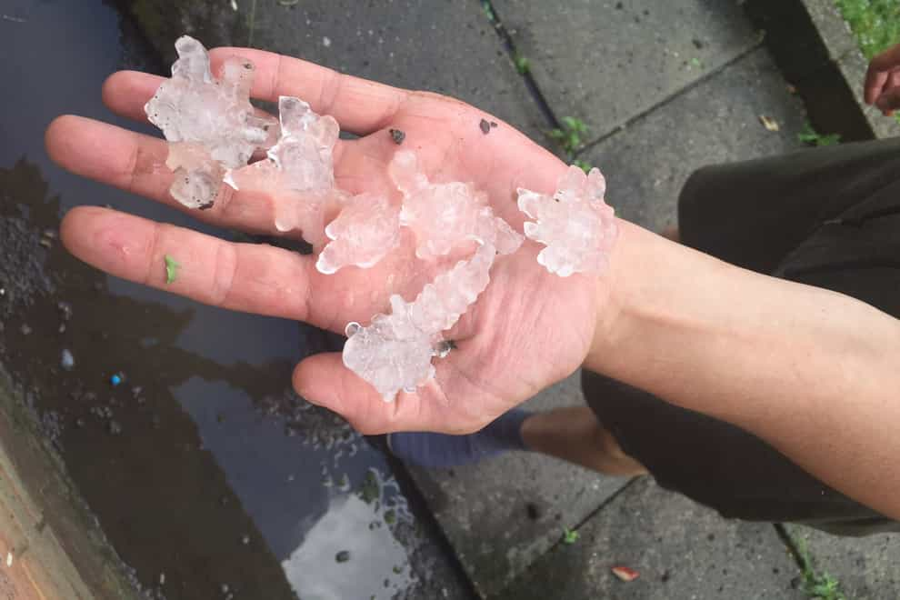
Hail stones the size of £2 coins have hit parts of northern England as thunderstorms and torrential rain continue to sweep across the UK.
Photographs posted on social media show people in Leeds and Sheffield holding handfuls of large jagged hail stones after they fell on Friday evening.
It comes as the Met Office warned thunderstorms could bring hail, lighting and flooding to parts of the UK, with up to 50mm of rain falling in an hour.
Met Office meteorologist Craig Snell said photographs he had seen show the hail to be about 3cm to 4cm in size.
He told the PA news agency: “Usually in the winter when we have hail it is quite small, but this time of the year, because the heat gives the thunderstorms more energy and helps keep the hail stones up in the clouds for longer, they get to grow more and then fall from the sky.”
A yellow weather warning for thunderstorms is in place for most of England, Scotland and east Wales until 9am on Saturday.
The south-west and the far south-east coast of England are not covered by the warning.
Mr Snell said: “Not everyone will see a storm, but if you catch one, you will certainly know about it.”
The change in weather comes as the UK experienced its hottest day of the year so far on Thursday, with the mercury rising to 33.4C (92.1F) at Heathrow Airport in west London.
Scotland and Wales also experienced their hottest days of the year so far, with the former recording 30.8C (87.4F) in Prestwick, and the latter seeing temperatures rise to 31.4C (88.5F) in Trawsgoed, near Aberystwyth.
Temperatures on Friday reached a maximum of 31.2C (88.16F), recorded at Kew Gardens in west London, the Met Office said.
The storms are expected to clear northeastwards on Friday evening, but will remain over north-east Scotland until Saturday morning.
The Environment Agency issued seven flood alerts – meaning flooding is possible – of which five were focused near rivers in the West Midlands, while others were for the waterways around Loughborough in Leicestershire and the River Trent tributaries in Nottinghamshire.
A further yellow weather warning for rain is in place for Scotland and Northern Ireland between 9am and 10pm on Saturday.
The Met Office said up to 20mm of rain could fall per hour in the areas covered by the warning, with up to 40mm falling over a “few hours”.
Sunshine and showers are forecast for much of England and Wales on Saturday, with temperatures expected to hover around 22C (71.6F).
Sunday is forecast to see rain and gusts of up to 50mph hit coastal areas in north Wales and north west England, while remaining “breezy” further inland, Mr Snell said.
Temperatures in the south of England are expected to be between 20C to 21C (69.8F), while the mercury could drop to 14C to 15C (59F) in the north and in Scotland.
The best videos delivered daily
Watch the stories that matter, right from your inbox