Residents urged to stay vigilant after ‘incredibly frightening’ floods
Communities are being urged to stay vigilant after “incredibly frightening” floods caused by heavy rain.
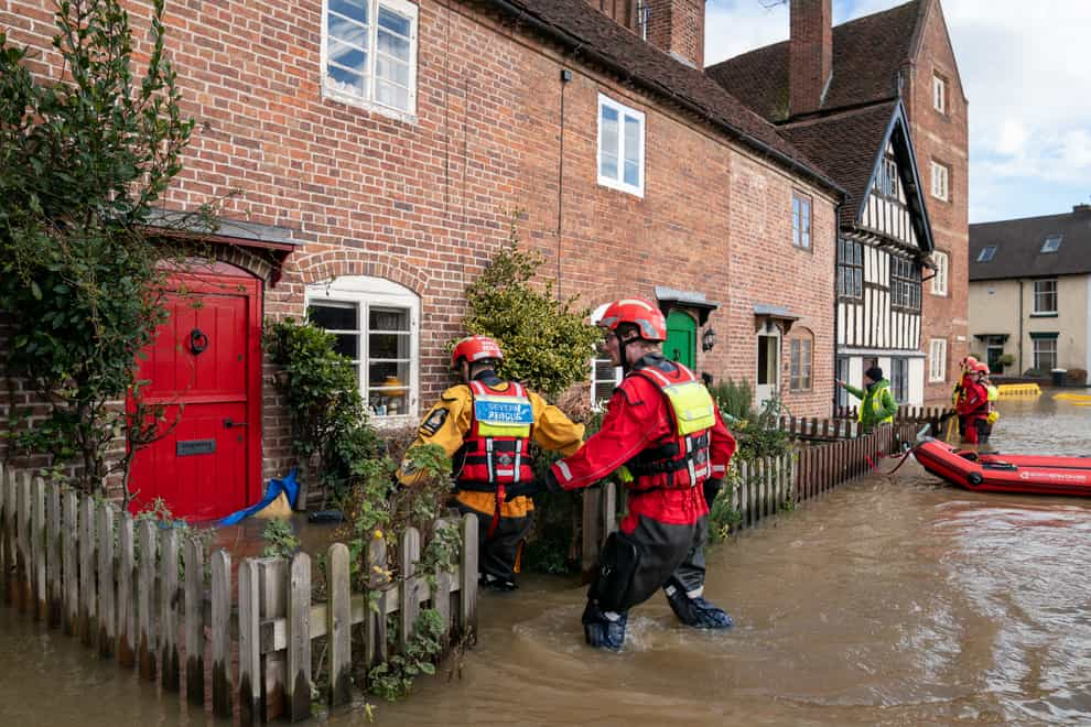
In Bewdley, Worcestershire, search and rescue crews were out checking properties and speaking to residents on Wednesday after temporary flood defences were breached following heavy rainfall on Tuesday afternoon.
The River Severn peaked in the town on Wednesday afternoon but levels are expected to remain high for a prolonged period and a severe flood warning, meaning a danger to life, is still in place.
The last week has seen storms Dudley, Eunice and Franklin cause problems across the country and about 400 properties have been flooded.
Meanwhile, the Met Office issued yellow warnings for wind, snow and lightning across parts of northern England, Scotland and Northern Ireland on Wednesday.
Dan Bond, flood duty manager at the Environment Agency, said: “We are still facing a significant flooding risk, and we are urging people to remain vigilant and take extreme care.
“Last weekend’s heavy rainfall on already wet areas continues to cause river flooding along the River Severn and is likely to continue over the next few days.”
Ross Donnelly, station manager for Shropshire Fire and Rescue Service, said: “We advise you to check before travelling, don’t be tempted to drive past any ‘road closed’ signs or move any ‘road closed’ barriers, which we have seen earlier today and that has resulted in a number of rescues which could have been avoided.”
Nick Green, area incident manager for the Environment Agency for the West Midlands, said it had been “incredibly frightening” for the community in Bewdley.
He said: “We could really see the anxiety and the worry that they had knowing that the river was going to rise and the impact that it could have on their lives.”
This is the fourth year in a row the town has flooded, with temporary flood defences also failing during Storm Christoph last January.
Mr Green said plans for permanent flood defences at Beales Corner in the town were under way.
He said: “We want to futureproof this system so the community behind at Beales Corner here in Bewdley has got the confidence going forward that they can live here free of any impact from the River Severn that flows through their neighbourhood.”
Further up the river, in Ironbridge, Shropshire, the council leader said the water was just 20cm away from breaching barriers.
Councillor Shaun Davies, from Telford and Wrekin Council, said: “It’s only through the grace of God that these barriers have not been topped again.
“This is the third consecutive year where these barriers have been put under significant strain and we will be lobbying Government over the weeks and months ahead for a more permanent solution.”
A council spokesman said: “Despite not breaching the defences, the area is still severely affected by flood waters and Environment Agency pumps are on site to reduce the impact as far as possible.”
A severe flood warning remains in place for the Wharfage in Ironbridge due to fears the temporary barrier system may fail.
As of 3pm on Wednesday, there were 52 flood warnings, meaning flooding was expected, and 43 flood alerts, where a flood is possible, in place.
The Met Office said weather was expected to stay unsettled over the next few days.
A yellow weather warning for wind was in force across north-east England, Cumbria, north and east Yorkshire and parts of Scotland from 6am to 6pm on Wednesday.
A second yellow warning for snow and lightning covers much of Scotland and Northern Ireland from 5pm on Wednesday until 8pm on Thursday – with the possibility of 10 to 20cm of snow building up on higher ground, strong blustery winds and a chance that showers could be accompanied by frequent lightning.
Met Office spokesman Richard Miles said: “For the areas experiencing flood impacts, that will stay the case for the next couple of days but there aren’t any additional impacts expected outside those areas.
“There will be rain across central and southern areas on Thursday so we will be seeing wet weather but not huge amounts of additional rain.”
He said there was nothing in the forecast for the next four to five days to suggest the UK could see another named storm but forecasters would be looking to see what was developing over the Atlantic.
The best videos delivered daily
Watch the stories that matter, right from your inbox